Wild Stories
about the great outdoors
Less than halfway, but proud thru and thru

On Sept. 26, I didn’t know when I set up camp at Howard Lake on the Kekekabic Trail that it would be the final night of my hike.
The week before, I’d had beautiful, mild weather on the Border Route Trail with temperatures in the 60s and 70s. Plenty of sunshine kept my spirits high, along with having the company of Michelle Schroeder, and getting to meet up with Patty and Dave Warner for the first time since Michigan.

Just as I finished my last blog post, Dave and Patty walked through the front door of the historic Clearwater Lodge. I gave them hugs, and gratefully accepted their offer to take me to lunch all the way down in Grand Marais, a 45-minute drive down the Gunflint Trail, so I could also get a new tent. The waterproofing treatment I’d given my rain fly hadn’t done the trick. I’d lucked out so far, weather-wise, but the forecast showed temperatures would be dropping into the low 30s as I headed onto the Kekekabic Trail, and there was plenty of rain in the forecast.
Patty, Dave and I ate pizza at Sven & Ole’s in Grand Marais, and caught up on the last two months we hadn’t seen each other. They’d just finished a two-week trip in the Boundary Waters. Our original plan had been to meet inside the vast wilderness area at Agamock Lake, but I’d moved too slowly up the Superior Hiking Trail. Once again, Patty and Dave’s good company and kindness gave me a boost in morale, and helped me solve a major gear issue.
New tent in hand, I returned to the lodge after the too-short visit with Dave and Patty, and found the room I was sharing with Michelle was cleared out of her gear. She’d left a note explaining she’d decided to head back out to the trail so she could hike all the way to the western terminus of the Border Route Trail. Her time was more limited than mine.
Michelle’s sudden departure was a bit jarring at first, like finding a “Dear Jane” letter. I wondered if my stench had driven her away, chuckling to myself. I admired her determination to finish as much of the BRT as she could. I realized I’d be hiking solo in the Boundary Waters for the first time, the eventuality that had so spooked me in Grand Marais that I’d stalled out for three days. Instead of fear, I felt excited to finally get to get some alone time in my favorite place on earth.
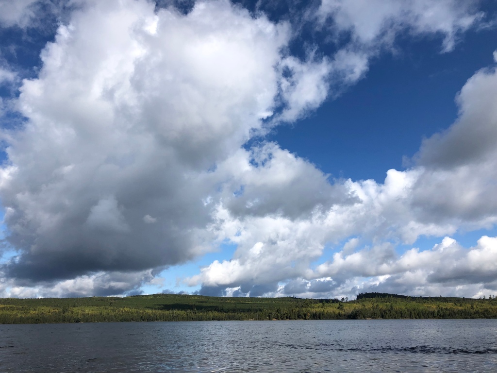
I headed out the next morning and had a perfect day of hiking. The first five miles from Clearwater Lodge to Rose Lake passed quietly beneath sunny skies, through woods perfumed by leaf litter. At the end of “The Long Portage,” I took a short break to enjoy the breathtaking view of the palisades on the Canadian side of the lake. I’m not sure what alchemy exists between lake and sky at Rose, but it always has the best clouds.
The trail climbed up from the lake shore onto the ridges high above, where I came mere feet from stepping on a porcupine, hidden from view by thimbleberry bushes growing along the trail. I backed up, and watched the porcupine watch me. It seemed nonplussed by my presence, neither scared nor aggressive. Every time I get to have a close, benign encounter with wildlife, I’m grateful, and this porcupine was an especially gorgeous specimen with glossy black fur and a mohawk of yellow-tinged quills running down its back.

I ate lunch at the Stairway Portage Falls, taking a little extra time to enjoy the view and a cup of coffee as I’d already hiked 2/3rds of my planned mileage for the day. One way that I dealt with my fear of hiking the Border Route and Kekekabic Trails solo was to plan shorter days. The Border Route Trail was in such good shape that it really hadn’t been necessary. I decided to make it to the spur down to South Lake, and then decide if I wanted to keep going.

I had vivid memories of losing the trail in 2017 for a full half hour after the Rose Lake Cliffs and Spire vistas. Between the forest fires of 2006 and 2007, and the derecho straight-line wind storm of 2016, the trail had been extremely difficult to hike and follow from this point west.
A couple of upturned root balls alongside the trail was the only remaining trace of the destruction I’d often described as being like a bomb had gone off in the middle of the wilderness. Campsites that had been closed in 2017 were open again. I reached the South Lake spur early, the day was gorgeous and my body was singing, so I kept hiking to Sock Lake.

My night in camp was perfect too. I arrived around 6 p.m. Pitched my new tent without issue, and cooked dinner on the rock outcropping over the lake as twilight descended. The still waters of the lake perfectly mirrored the forest on the far shore. The peace and quiet stole into my soul. And because the sun is setting so much earlier now, I was awake late enough to see the Milky Way for the first time since I was a child.
With the trail in such good shape and only 12.5 miles to go to the turn off for the Gunflint Lodge, where I’d mailed another resupply, I suspected I’d get to the resort a day earlier than planned. This would be the first time I’d gotten somewhere earlier than planned my entire hike.
I had a leisurely morning in camp, thoroughly enjoying the sunrise over Sock Lake along with some oatmeal. I would be exiting the Boundary Waters in just a few miles when I reached the Crab Lake cut off trail. I wanted to savor the beauty of the Boundary Waters, but knew I’d get more on the Kekekabic Trail too.
As the trail neared Gunflint Lake, I braced myself for the brush to make navigation difficult. During my previous hike of this trail, the brush was so overgrown that my dog couldn’t even find the trail with his nose. On the western 12 miles of the BRT, forest fires burned back the forest, allowing brush and young trees to claim the space. The brush of 2017 ultimately ended that hike early as my hiking partner wrenched his knee so badly on an unseen rock that we had to ditch out on Loon Lake Road.
I had no issue this year with the brush, a product of trail maintenance, and also hiking in late September versus mid-July. The brush was already dying back from cold nights.

I hiked down the short spur trail to Bridal Falls, which were running pretty low despite the near constant rain the area had received since late August. Before long, I reached the crossing of Loon Lake Road, and headed onto a new stretch of trail. The stretch on top of the Gunflint Cliffs was amazing hiking. As I reached a vista, I realized I was looking down on the Gunflint Lodge, where I was heading for the night. If I’d had any rock climbing skills, I could’ve just scaled down the 200-foot cliff, but I don’t.
One of my favorite parts of hiking the Border Route Trail is that it gets you up on top of the ridges you see when you canoe through this area of the Boundary Waters. I’ve wondered so many times what it’s like up on those palisades and cliffs. Now I know; it is the domain of raptor, where hiking feels more like flying, where the winds are stronger out of the cover of the forest and the water far below.

I climbed down from the cliffs and started navigating through a maze of ski trails, which BRT hikers often report can be tricky, but all the junctions were well marked and easy to follow. I had no difficulty. I did notice that the Gaia GPS map of this section of trail between Loon Lake Rd. and Cty Rd. 20 was wrong; it shows the trail running below the cliffs, not on top of it. I trusted the trail signage instead of my app.
I reached the lodge by 6 p.m. I probably should’ve realized something was up with me when I didn’t immediately go eat a cheeseburger. I didn’t bother eating dinner at all that night.
I cannot sing Gunflint Lodge’s praises enough. On two separate hikes, they have not only been willing to hold resupply boxes for me, offer $18 bunkhouses (cheaper than many campgrounds where I stayed on this hike), they’ve also been genuinely excited by my treks. Way back in Pictured Rocks National Lakeshore, I’d met an awesome group of Boy Scouts and discovered one of them, Cameron, would be working at Gunflint Lodge for the summer. “I’ll see you in 1,000 miles,” I’d said.
“Cameron is going to be so mad that he missed you,” Dana told me, another employee at Gunflint. I was disappointed I’d missed Cameron too, but thrilled to hear I was missing him because he was on a canoe trip in the Boundary Waters.
I picked up my resupply box from Dana, a BWCA permit for the Kekekabic Trail, and turned in early. The next morning, I finished the remaining 6.5 miles of the Border Route Trail, which took me past Magnetic Rock, which set my compass spinning all directions except north. The weather had changed the evening before. Gone was the warm sunshine; in its place, blustery winds drove patchy rain clouds in waves above, periodically blocking the ever weakening sunshine. When the sun was out, I could hike in my T-shirt. The second the clouds covered its light, the temperature dropped ten degrees. My day became an annoying game of putting layers on, then taking them off, then on, then off.

I was having a great time, but a stomach ache was dampening my mood a bit. It wasn’t uncommon for me to have a small tummy ache on trail; usually they just signaled to me I could expect to be digging a cat hole within the next mile. But this one strengthened throughout the day.
I crossed the Gunflint Trail, walked the tenth of the mile south to the eastern Kekekabic trailhead, and hiked the first three miles to a campsite on Bingshick Lake. For the first time since late spring, I chose a tent pad out of the wind as a cold breeze was gusting in from the lake. I cooked a big, hot dinner, despite having no appetite and turned in. After hiking 1,500 miles, it’s a peculiar feeling to not be hungry. Hunger becomes a constant companion, something to which you just adjust as being part of your daily life. Eat a Cliff bar, get 15 minutes without hunger. That’s about it.
Around 7 p.m., tucked cozily into my down quilt, an animal suddenly sprinted past my tent toward where I’d hung my food bag. For the first time on my hike, I grabbed the pepper spray I keep in my tent; I was convinced it was a bear. Almost dark, the thought of other humans coming into camp didn’t even occur to me. The animal ran back toward me. My heart was pounding. Then I heard voices. Relief flooded over the adrenaline as the group hiked past to another campsite down the trail. The sprinting animal was their dog.

I headed west on the Kekekabic the next morning toward Chub River and the Seahorse Lake narrows, a stretch of trail that in 2018 actually made me yell in frustration because I found it so difficult. The brush and rocks along this stretch had been exhausting. But like the Border Route Trail, the Kekekabic was in amazing shape. I, however, was not.
I struggled down the trail not because of trail conditions but because my stomach ache had gotten much worse, and was now being accompanied by severe nausea and stomach pain. Fatigue slowed my pace to a crawl. I took lots of breaks and tried to force myself to eat, but when I’d only made it five miles by lunch, I decided to set up camp early at Howard Lake. I hoped that eating a lot of food, and getting lots of sleep would make me feel better.
I spent the day reading and eating, soaking in the true peace and quiet of the Boundary Waters, which I’d entered again just before Bingshick Lake. I cooked a Camp Chow Chili Mac meal, even adding some cheesy instant potatoes, and forced it down. This may go down in my memory as the worst meal I’ve ever eaten, not because the food was bad, but the nausea was so bad that I wanted to vomit every other bite. On trail, there is little that can be done to make yourself feel better besides eating and sleeping. I tried both.
The next morning, I slept late, waiting out a cold rainstorm. I didn’t feel better, but I also didn’t feel worse. My stomach hurt, and I couldn’t eat. I sat in camp, trying to decided whether or not to keep going west, or turn back to Gunflint Lodge to wait out this illness. To the east, help was at least 30 miles away to the first resort, and about 50 miles until the town of Ely. The Gunflint Lodge was only 8.5 trail miles and a couple road miles behind me. As I sat and struggled to make a decision, a pack of wolves started howling nearby. I sat, enthralled, guessing they were within a half a mile. I’d never heard wolves so close.
I decided to backtrack to Gunflint Lodge. At no point during my 1,500 mile trek did I feel I was on a forced march. I did that final morning. Every step I took was in service to getting myself off this trail, nothing more. I felt terrible, waves of stomach pain and nausea getting worse. I couldn’t eat at all. My body switched on whatever reserves it keeps for emergencies and got me off that trail.
When I reached the lodge, I called my mom to alert her to my change in hiking plans. When I’d checked back into the bunkhouse that Friday, staff let me know the outfitting side of the lodge, which operates the bunkhouses, would be closing the following Monday. I had two days to figure out if I could keep hiking. One positive of being forced off trail by my illness is that Cameron was back from his canoe trip when I came back to the resort. We got to meet up again, 1,000 miles down the trail!

That night, the temperature dropped below freezing for the first time. I was indoors, but the bunkhouses are unheated. Wearing my warmest layers, I could not stay warm. My feet were like blocks of ice. I still couldn’t eat, and around 3 a.m., I woke with an explosion of pain in my gut. I sprinted up the hill to the communal bathrooms, barely making it in time. I spent the next 36 hours in major distress, and wishing for some adult diapers.
Sunday morning, after having a horrifying and simultaneously humbling overnight of incontinence, I decided to go home. The bunkhouses closed the next morning, and I was getting worse. The idea of trying to find other accommodations nearby felt exhausting, much less returning to a trail that runs 40 miles through wilderness in cold, wet conditions. Snow was in the forecast. How could I hike if I couldn’t eat? How could I stay warm?
I knew my hike was done for the year. And I was proved right by the length of my illness once at home. Whatever illness I picked up was not a garden variety upset stomach. I’ve been sick for more than two weeks, unable to even write this blog post. I went from being in the best physical shape of my life to struggling to walk my dog for more than a mile on nice, easy sidewalks. In the time I’ve been sick, the first heavy snows of the year arrived where I’d been hiking.
I learned today that a dehydrated PackIt Gourmet meal I ate on the Border Route Trail, the Big’un Burrito with Fajita Chicken, was recalled Oct. 9 due to possible Listeria contamination. I’m not sure yet that this meal is what made me sick. The company is saying no confirmed cases of illness have been reported to the USDA. I have a doctor’s appointment Wednesday when hopefully I can found out more.
I’ll confess, this was not the dramatic ending I’d envisioned when I set off on this journey five months ago. But I am not discouraged or disappointed, far from it. One thing the woods taught me very quickly is acceptance. Acceptance of the rain, the heat, the mud, and the bugs. The woods also eventually taught me to accept my physical limits, although I fought it. I couldn’t tell if I was failing to hike my mileage goals because of physical limits or a failure in mental fortitude. This time, I listened to my body, gave it a few days to talk to me, but ultimately accepted I couldn’t continue when that became clear. I didn’t beat myself up. I didn’t doubt my judgment. I count that as a win. A loss would’ve been continuing down the Kekekabic in an effort to protect my ego and getting myself into a worse situation.
I’m proud of my failure to hike half of this trail because hiking 1,500 miles just doesn’t feel like a failure. Those miles took everything I had. I met the greatest people. I saw incredible beauty. I made the woods my home for five months, and the woods welcomed me.
Every long distance hike is a question: Can I do this? I’ll write more in-depth on this soon, but after reading and watching so many people thru-hike other National Scenic Trails, I wanted to find out if there was some specific lesson to be learned by hiking 2,000+ miles. For me, there wasn’t. For me, distance is not the most important part of a long-distance hike or a thru-hike, it’s time. I think this is the real difference between thru-hiking and week or weekend trips.
This story is not over. I plan to write more about how this journey changed me, what I learned, and what my re-entry back into city life is like. I want to write some practical things too, tips for other long-distance hikers coming after me, a post about my gear, and an analysis about why I think I failed at hiking half the trail in a single season. Alex, my video editor, and I still have 700 miles of video to edit and release, which I hope to do more frequently now that I’m off trail.
I hope to pay forward all the trail magic gifted to me. I want to help other hikers of the North Country Trail. I want to join trail maintenance trips, paint blue blazes, lop brush, follow the buzz of a Sawyer down the trail and help clear downed trees from a path that now means the world to me. Once I find a new job, I plan to donate regularly to the trail. I want to be one of the thousands of people who are determined to see the 2,000 remaining road miles turned into trail miles.
So here comes the part where I finally ask for money, but not for me. To celebrate the end of my hike, I’d like to do a fundraiser to thank the North Country Trail Association and its chapters.
In total, I hiked 1,506 miles of the North Country Trail. My hope is to raise $1,506 for the North Country Trail Association, $1 for each mile I hiked. If you’ve enjoyed following my hike, reading this blog and watching the videos, please donate by clicking on the link below. In the “Comments” section of the donation page, please write “Annie’s hike”. The NCTA plans to track donations so we will know when we’ve reached the goal.
If you’d like to contribute in a non-financial way to the trail, please consider joining your local chapter or volunteering to do trail maintenance.
To all the trail angels who hosted, fed, encouraged and supported me: The moments I shared with you shine in my memory as brightly as the stars in the Milky Way. Your generosity and kindness were the most unexpected wonder I experienced on my trek. From the bottom of my heart, thank you.
To all chapter members and volunteers: Your dedication to this trail was amazing to witness. You’ve inspired me and shown me the joy found in building this trail. Every step I took past a cleared downfall, a confidence marker, a clear blue blaze, a freshly mowed trail, I thanked you in my mind. From the bottom of my (still) aching feet, which ache much less than they would’ve thanks to your hard work, thank you.
To everyone who’s been reading the blog, watching the videos, and sending comments and emails: You made my hike better, less lonely. When I saw something magical on trail, I enjoyed it more because I knew I would get to share it with you. From the other side of the computer screen, thank you.
To my family and friends: Despite all evidence to the contrary, none of you treat me like I’ve lost my damn mind. Despite running away to the woods for months at a time and missing out on important events in your lives, you cheered me on. Your support meant the world to me. I missed you all terribly. I’ve got so many hugs saved up!
And finally a special thank you for my mom: Thank you for taking care of my dog for five months. Thank you for helping keep me safe while I was on trail. Thank you for shipping random boxes to random places. Thank you for always having time to talk to me, even when you’re on literally on your way to “Hamilton” in Chicago. Thank you for driving six hours to the Canadian border to rescue me off the trail. Thank you for preventing my homelessness by allowing me to stay with you while I now look for work. I could not have done this without you. I love you to the moon!
Happy hiking everyone!

Annie- your hike was such a great adventure. Each person’s is different, and I can tell you’ve also caught the NCT hiking bug. That one it totally persistent. You’ll never shake it! Hope we can hike together again sometime.
LikeLiked by 1 person
I so hope we get to hike together again! Getting to meet you right off the bat set an amazing tone for my hike. I suspect you are right, that some day I’ll be able to join the ranks of the end-to-end hikers. Only 3,100 miles to go!
LikeLike
Thanks to your videos I was inspired to do my first solo trip on the NCT in Michigan. It may have just been three nights, but it was a totally new experience, and I know I will be hiking more. I have enjoyed your videos so much with your struggles and honesty as well as joys and triumphs. I wish you a full recovery and good transition back.
LikeLiked by 1 person
Christy, your comment is the reason why I’ve written this blog and made the videos because so many people did the same for me. I’m so happy that you did your first solo on the NCT! Truly, I’m grinning ear to ear!
LikeLike
Annie, a wise decision. Giardia or listeria seem like possible culprits. I’m sure it won’t be long until you continue your journey. And when you’re ready to volunteer, we’d be happy to see you in NW Wisconsin.
LikeLike
Thank you, Peter! I would love to come volunteer with the Wisconsin crews, and learn how you keep your trail in such amazing shape.
LikeLike
Great! To get on the list for announcements of Wisconsin Roving Trail Crew projects, contact Bill Menke, bmenke@northcountrytrail.org. They work once a month from April to November.
LikeLike
I am and will always be very proud of you for accomplishing all that you have!
LikeLike
Annie…the rest of the Kek will wait for you once you are in the groove and ready to move. You were wise to recognize your malady and to head back to Gunflint. Enjoy your R&R. Reflect on your journey and be proud.
Love that Sock Lake site. Your photo made me remember it fondly.
Shug
LikeLiked by 1 person
Thanks so much, Shug. That Sock Lake site was gorgeous. I especially appreciated the nice white pines that offered an easy bear bag hang, haha. My malady ended up being Giardia, a.k.a. beaver fever. It SUCKED.
LikeLike
I’ve thoroughly enjoyed following along on your excellent adventure. What a huge accomplishment! I look forward to the videos and continued posts. You are such an inspiration. Wishing you a quick recovery.
Thank you for sharing.
LikeLike
Thank you, Ann! I am feeling back to normal now, but it took 2-3 weeks and a handful of pills to get me there. Thanks so much for following my hike. It’s been a pleasure sharing it with everyone.
LikeLike