Wild Stories
about the great outdoors
The Trap Hills start to feel like a trap

Panting like a blown race horse, leg muscles shaking with fatigue, I reached the top of another breathtaking view in the Trap Hills of Upper Peninsula Michigan.
I should be feeling awe right now, I thought. Instead, looking at the giant hills stretching before me, knowing I’d have to climb up and down them too, I felt real fear for the first time on this hike.
Something was wrong.

I’d been warned about the Trap Hills since before starting my hike. Before entering the hills, I’d stopped at Old Victoria, the preserved 19th Century mining village on their east side. Mary, a woman who works at the village, told me something I hadn’t heard before. She said the Trap Hills have the most elevation change on the entire North Country Trail. That means lots of climbing up and down, and up again, and then down again.
The hills are also in one of the most remote parts of the UP. There are very few towns west of Marquette. Remote is a pretty mild word for, if something goes wrong, it’s going to be much harder to self-rescue.
For a trail that includes the Adirondack Mountains in New York, and the Superior Hiking Trail (SHT) in Minnesota (which has about 41,000 feet of elevation change), Mary’s fact about elevation change in the Trap Hills shocked me. My apologies, Mary, but I doubted it was true. I’d been told by another person who’d hiked the SHT that I’d be just fine. I figured the ups and downs would feel similar. The SHT is hard, but I’d successfully thru-hiked that trail in 2017.
So why were the Trap Hills feeling more like a dangerous trap every mile that I hiked? Every climb left me more sapped. Every downhill scared me more, especially after two days of thunderstorms drenched the forest, making the gorgeous rocky hilltops slippery, and turned a dirt trail into slick mud.
I’d taken a bad tumble my first full day in the hills, and fell onto a pointed rock. The rock was blunt-edged, I was lucky, but it felt like I’d taken a hammer to my left glute. The pain was so intense at first, I thought I’d done serious damage to my muscle. Every step hurt. Gradually the pain faded, unless I was climbing or descending, which I was doing constantly. I couldn’t sit without pain, which I was also doing constantly as my fatigue grew.
I’m hiking about 15-20 miles a day, day after day. Fatigue and pain are a daily reality. I’m always trying to assess whether or not the pain and exhaustion I’m feeling is dangerous or just hard. I push myself past my limits, successfully, all the time. But I’ve never hiked more than 800 miles in two months. I haven’t had conditions like heat exhaustion or muscle tears. I don’t know what they feel like. The unknowns are what make this experience an adventure, but also scary at times.
I’d been struggling physically before reaching Marquette 10 days earlier. I worried I was doing something wrong. Shouldn’t this be getting easier? Shouldn’t I be feeling stronger?
“No, it never really gets easier,” Alex Maier, my video editor, told me as we were literally sitting on Top of the World, a popular high point outside of Marquette. Alex and I met up while I was in Marquette. He has hiked some seriously difficult trails, the Pacific Northwest Trail and the Hayduke Trail, as well as the entire NCT in the UP.
A campfire burned at our feet, and the sun set behind us as we talked. The forest stretched below us to the shore of Lake Superior, which stretched to the horizon.

Alex’s comment didn’t discourage me, quite the opposite. He helped me realize I wasn’t really distressed by my performance on trail; I’d made it all the way to Marquette, after all. I was distressed by my expectation that this would get easier. “You do build more stamina,” Alex said, “but it never feels easier.”
I hadn’t been seeing other hikers on the trail, much less experienced long-distance hikers. I peppered him with more questions. He generously answered them all, and many of his tips have improved how I’m feeling on trail. In the heat, he said, “camel up” on water when you reach a water source, or drink as much as you can while at the water source. He also recommended eating a lot of food at night. “I think it helps your body recover better at night,” he said.
I confess, sometimes I’d set up camp so late and so tired, I’d just stuffed a Snickers bar or some cheese in my mouth to take the edge off my hunger and go to sleep.
The camaraderie I felt with Alex, his understanding of my experience, was a huge help.
I’d also been re-energized by the potluck with North Country Trail Hikers Chapter members. To be literally surrounded by people who love the outdoors, and this trail, was so fulfilling. We discussed everything from specific parts of the trail to gear to the physical changes you experience when long-distance hiking like a heightened sense of smell. We also talked about how spending long periods of time affects your spirit.
I told a story about hiking through a huge stand of old maples. Their branches soared a hundred feet above, growing toward each other to create natural arches crowned by jewel-green leaves. A rain-muted light filtered through the leaves. The filled-in canopy allowed only shade plants to grow, which in mid-June meant a thick carpet of blooming trilliums, violets, and freshly unfurled ferns. I’d been hiking in this amazing landscape for a while when the rarity of its beauty finally hit home.
For hundreds of feet in all directions, this cathedral of maples stretched. Because we logged almost all of the old growth timber in our country in the 1800s and 1900s, it is rare to see big groves of old trees.
I stopped dead in my tracks. The beauty of these woods felt sacred. I was overwhelmed by how lucky I am to be alive on this amazing planet, to be a human on it. Gratitude filled me to my fingertips. I was shocked to find myself crying. I’ve had some awesome moments in the woods, in the truest sense of the word, but I don’t know that I’ve been moved to tears before.
Thank you North Country Trail Hikers Chapter members for coming to the potluck. Your food was delicious, but your company and conversation fueled me in more important ways.
So I was feeling really good as I started working my way west out of Marquette. North Country Trail Hikers Chapter President Lorana Jinkerson hosted me for five days total. Her company was a joy to have, and her help a true gift. Not only did she invite this stranger into her home, and run me all over town to get supplies, she also shuttled me to and from the trail for three days, which allowed me to slack pack and get a running jump on the long, remote stretch of the Western UP. She drove as far as an hour on rough gravel roads to do this kindness for me. (And I’m really mad because I forgot to get a picture of Lorana and me.)
The day before I headed out on my own again, I managed to get lost on a road walk. Only by chance, Lorana found me off course. If she’d driven another way to meet me, we might’ve had a very late night. We headed back to her house. I’d ended the day 3.5 miles short of my goal, but it was more road walking, so I hoped to make it up easily the next day.
Lorana dropped me off at my wrong turn the next morning, and gave me a warm hug. Transitioning back to solo trail life after such good company in town grows increasingly difficult. I miss my people. I miss my dog.
I’d been advised to plan on hiking only 15 miles a day on this stretch as the trail gets much more rugged. I turned off the road onto trail above the Silver Creek Basin, and soon found myself in an aerobic workout from the constant up and downs. I loved this stretch of trail high on the ridge with views of the creek below, but not only did I not make up my miles, I ended up even further behind when I gave into my exhaustion and camped early after hiking just 11.5 miles. I had exactly the amount of food I needed to reach my next resupply six days up the trail. I couldn’t get further behind.

In camp that night, I discovered my shoes were starting to get holes and separate from the soles. The next morning, I sewed them up with floss, and hoped they’d hold until Ironwood, my next town stop 10 days away.
I headed into the unblazed McCormick Wilderness, which was rugged, beautiful, and hard hiking. The going was slow, and made slower by a flagged reroute I chose not to take at first. I’ve followed flags on a wilderness trail to a dead end before, so I wanted to check the original trail for myself before heading off into an unknown. Sure enough, a beaver dam had flooded the trail right up to a rocky cliff. I backtracked and followed the new trail without issue.

Another flagged trail appeared. Now trusting that flags meant a reroute, I followed them only to emerge into a clear cut. They don’t log wilderness areas. I checked my GPS. Sure enough, I was off trail and out of the wilderness area, but in a beautiful, mosquito-free meadow full of wildflowers, so I ate lunch and then back tracked. When I got back to the place where I’d gotten off course, I noticed two flagged routes, one with orange tape, and one with orange and pink tape. Follow the orange and pink flags if you hike in McCormick.
It’d taken me about six hours to hike 8 miles, but after the wilderness area, the trail was flat, and beautifully maintained, all the way to Craig Lake State Park. On the way, I saw a pond filled with more wild iris than I’ve ever seen in my life, thousands!

I’d seen my first moose tracks and scat on the trail above the Silver Creek Basin, all along McCormick, and into Craig Lake State Park. As I was falling asleep in my tent that night, I heard a moose walk through a small pond about 20 yards from my tent. I’d managed to catch up a couple miles that day, my shoes had held together, and I was happy.
I incorporated the croaking of the bull frogs into my dreams that night, slept hard and deep, and woke feeling amazing. I hiked quickly through the park, and down the road walk past Cozy Inn, where I’d planned to eat and grab more water, but they were closed. The rest of my day would be walking on roads. With little water and the heat and sunshine beating down, I took a long break by a small river. The heat is oppressive earlier and earlier in the day now, and lasts into the evening as the sun is up until 10 p.m. I was tiring out earlier each day. Every day, I’d try to get up earlier to get more miles done before the heat set in, but the heat was also slowing me down so much that I’d get to camp late, and so tired that I just couldn’t bear to give up the sleep to get going earlier.
I made up another 3.5 miles to a small parcel of public land about 500 yards from M-28, a state highway. I fell asleep the sounds of logging trucks roaring by and the alarmed bugles of deer in the woods around me. I feel bad for spooking them, but love having the deer close. Dispersed camping gets me closer to the creatures who call the woods home.
I managed to get hiking earlier the next morning, and had a beautiful break at the Humpback Bridge over the Sturgeon River. I found dozens of perfectly ripe strawberries, and ate them along with my morning snack.

I followed a gorgeous new trail between the bridge and Canyon Falls gorge, the Grand Canyon of the UP, as the Peter Wolfe Chapter calls it. The falls reminded me of many on Minnesota’s north shore like the Temperance and Split Rock gorges. I should have spent more time there enjoying the beauty, but pushed on and made my first major water mistake. I opted not to fill up on water at a bridge crossing because the trail appeared to run alongside the bank a mile further. Nope! I was entering the Baraga Plains, a sand plain that is hot, dry, and planted with young, shadeless tree plantations. I had a liter of water for the next 8 miles. My only other water sources were scummy ponds that would likely clog my filter.

The trail was level, and clear, so I hiked at a speed right below my full exertion level, and did fine until I hit a clear cut a couple miles out from Big Lake State Forest Campground, where I planned to camp for the night, and where there would be cold well water.
In the clear cut, the trail was destroyed. Slash, the debris left over after logging, was all over the tread, which in many places had also been completely destroyed by heavy machinery driving over it. Tall ferns were filling in the clearing, making the going difficult as I pushed through brush and stumbled on slash debris I couldn’t see beneath them.
The chapter does an amazing job of blazing on this section, thankfully, because often I couldn’t find the tread. I frequently got off on animal trails too. Eventually, I gave up on trying to find the tread and just made straight for the next blaze.
When I finally reached the road to Big Lake, I ran to the water pump. As the cool water hit my throat, I felt pure joy. I’d also finally made up all the miles I’d gotten behind.
Even at Big Lake, which is a big, marshy Lake, there were no mosquitos. I reveled in being able to sit late into the dusk at the picnic table, eating and journaling. After so much dispersed camping in dense forests, a picnic table feels like 5-star accommodations.
I woke early the next morning, eager to get hiking and meet up with Sara Wall, a local woman familiar with the NCT, who also works in the Ottawa National Forest. I headed out of camp and into another couple miles of trail destroyed by clear cut. I really wish that forest managers would leave the tread in tact, and a corridor of just a couple feet of trees on each side for the trail. National Scenic Trails are supposed to have a mile of forest corridor around them. A mile corridor is not always feasible, especially on private lands, but on public lands like the Baraga Forest Management Unit where I was hiking, I wish they’d leave at least a small corridor for the trail.
I’m not a trail builder. I’ve only ever done clearing trips before, but as I hiked these miles of clear cut, my heart sank for the Peter Wolfe Chapter at the amount of work that would be required to re-establish a tread on this section. I think it would take years of intensive work for a chapter that already manages a long stretch of remote trail with many of their members living 200 miles away or more.
I finally got out of the clear cut, and back to the Sturgeon River where I met Sara, and her dog, Guy, walking down the trail. Sara and I hit it off immediately. She was the one who clued me into the fact that we were in the Baraga Plains, and what that meant. “The sandy soil drains quickly, that’s why there are so many Jack Pines here, and no bugs,” she said.

Sara works for the Ottawa National Forest, so I eagerly asking her a bunch of questions about logging, and tree types. We talked about her time in Minnesota living in a yurt, the animals she and her husband raise here, and so much more. Just having someone to laugh with was amazing, but Sara also brought us a snack of fresh veggies and homemade chèvre cheese from her goats, and cold Gatorade. She cached water further up the trail for me on what would have been a 12-mile stretch in very hot, dry, sun-blasted conditions without water, which allowed me to camp earlier and reduced my risk of getting heat exhaustion or dehydration. When she and Guy turned back to her truck, I was sad to see them go. Thanks so much for coming to hike with me, Sara, and for caching water!
I continued on through the pine plantations before a forested area started again. I felt like I was melting in the heat and sun. I’ve come to accept during this hike that I am probably never going to be a desert hiker. I need shade like fish need water. Thanks to Sara, I was able to camp in a gorgeous oak grove with a clear understory. I expected some nighttime visitors because porcupine and deer scat carpeted the forest floor there. Sure enough, various deer came and went throughout the night.
The next morning, as I started hiking, I felt like the luckiest person in the world to be in the exact place I was, doing what I love to do. The trail returned to the Sturgeon River again. I saw a family of ducks swimming down the river as I filled my water bottles. The sand plains ended, and the bugs gradually returned as I hiked up and over low ridges cut by creeks like Wiggle Creek. There’d been so little rain in the past few days, many of the creeks marked on the maps were either dry or were more puddle than creek.
I discovered a new mosquito trick when I took a break on a forest road in the sunshine. During bug season, roads have become my favorite place to take a break because the bugs are sometimes a bit lighter. There is less foliage for the mosquitos to hide from the sunshine. I discovered if I get into the sun, and then starting swatting the swarm I’ve collected around me, they mosquitos don’t come back right away, and I can have a few minutes to peacefully eat a snack.
I was hiking toward Bob Lake Forest Campground. The closer I got, the thicker the mosquitos got. If I’m remembering correctly, Luke “Strider” Jordan (2013 NCT Thru Hiker) spent the night in a latrine because the bugs were so bad. The swarm became one of the worst I’ve ever experienced about 6 miles west of Bob Lake.
I put on my bug shirt, head net, and bug mittens for the first time since I’d left Marquette. I was meeting up with Patty and Dave at the campground. They’d generously picked up a resupply box I’d left with Lorana, and I planned to take a rest day and hang out with them at the lake.
The closer I got to the lake, the more intense the bug swarm got. Patty had planned to hike down the trail to meet me. I started hiking faster, hoping to intersect with her before she came too far down the trail and got swarmed. I made it all the way to camp in my full bug armor to find Dave sitting placidly by the lake. “That guy is so tough,” I thought, before Patty caught sight of me and exclaimed at the number of mosquitos around me. Apparently, there weren’t any mosquitos by the lake! “Hold on,” I yelled, “Let me kill these guys before I bring them into camp.”
I spent five minutes swatting myself, then went and gave Patty and Dave hugs, and stripped off my bug net armor. Patty handed me a sweating, ice-cold sparkling water, and it was the most delicious drink I’ve ever had.
The next day, Patty, Dave and I had a Perfect Day. We woke around 7 a.m., drank real, hot, perfectly brewed (by Dave) coffee. Around 9 a.m., I jumped in the lake in my bra and underwear, then walked to the back of the campsite away from the water to take a camp bath, washing myself and hair with biodegradable soap, and rinsing off with water Patty generously heated up for me. A hot shower on trail! Divine.
We ate an amazing breakfast of blueberry pancakes, bacon, sausage, eggs and juice, and sat and chatted until about 11 a.m. I started doing my rest day chores like getting my food bag ready for the next day.
As I packed up my food, a huge crack of lightning released a deluge from the sky, which built until hail was falling. After a light lunch, I took a long nap while Patty and Dave went for a hike down the spur trail. We cooked dinner over the campfire, and then went for what Patty calls a “Sunset Cruise” in the canoe, a paddle around the lake as the sun set. The water was still, perfectly reflecting the sunset to the west, and the moon rising to the south.

Patty and Dave offered to help me slack pack the following day, so I planned to do my first 20-mile day since east of Marquette and meet them around 7:30 p.m. at O Kun de Kun Falls.
I don’t remember much of the trail between the Bob Lake spur and 8 miles west when the mosquitos finally eased up, because they were the worst of the entire trip. My mosquito mittens were a failure. Anywhere the bug netting touched my skin was layered with bites. I ended up hiking without my trekking poles or netting on my hands because I found walking down the trail slapping my own hands in a kind of rhythm game was the best way to keep them off. I moved fast, though. I hiked 10 miles by lunch.
As I arrived at a small river, my next challenge was getting through a huge patch of Wild Parsnip, which has sap that can cause a poison-ivy like reaction if it gets on your skin and then is exposed to sunlight. The parsnip plants are getting huge now.
The brush was thick on this stretch of trail, the going hard. I came to a small creek and was shocked to find when I put my trekking pole in that it was at least four feet deep. I walked up and down the bank looking for a shallower place to cross, but the soil is turning to clay now, so when I tried to ease across the water, I still slipped and went in up to my hips. Nothing like an unexpected dip to refresh you!
Next, I came across a porcupine sitting on a tree that had fallen across the trail. It just sat there, totally still, staring at me. I stared back. Suddenly, it moved and appeared to be climbing down the log toward me. I quickly moved back. The porcupine changed course and instead moved off to the right side of the trail, or so I thought. As I was walking up to the log, it reemerged from the woods and walked the other direction on the log, eventually disappearing into the brush. I waited longer to make sure it was gone, then hopped over the log and continued on my way.
The Peter Wolfe Chapter plans to do a reroute on the next section, which consisted of clambering up and down hazardous, clay-filled washouts along the trail. I almost lost my shoes several times, but I was feeling really strong, moving fast, and having a great time now that the bugs had eased up. I was feeling so good, I wondered if my body had reached a new fitness level, and I could expect to feel this strong more consistently.
Just after I emerged from the woods beneath O Kun de Kun Falls, Patty crossed the huge bridge spanning the river. We took a picture in front of the falls, and then headed back to the car where they’d packed a hot dinner for me. They spoil me! We went and got ice cream in Mass City for desert, and had another campfire before going to bed. I was very sad to be leaving their amazing company the next day.

After a delicious breakfast of egg sandwiches, I gave Dave a hug goodbye, but we have hopes of meeting up again one more time even further down the trail for our most epic reunion yet. We’ll see! Patty dropped me off where we’d met up the previous night, and we hugged goodbye as well.
The trail to a ford of the Ontoganon River was quiet, level and perfectly clear. This ford had an interesting warning; the crossing was below the Victoria Dam. If I heard sirens blowing just before or during my crossing, I was supposed to not cross or go back as a wall of water would be coming my way. The siren sounds when they release water from the dam. We hadn’t had too much rain, though, so I figured I’d be safe. When I got to the ford, the river was low enough to rock hop. I filled up my water bottles and then began the long, hot, sunny climb on a road up to the Old Victoria Mining Village. I felt totally fried by the time I reached the top. I took a lunch break at the shelter there, and had a very hard time not just calling it quits for the day right then.
Eager to see this restored historical mining village, I pushed on. The trail enters the village from the back. I saw a woman working in one of the buildings, and went to ask her if there was water in the village. The chapter guide for this section said there might be a water pipe behind the cabins, but the one I found definitely didn’t look safe to drink. Orange rust and slime covered a trickling pipe. And so I met Mary, an employee at the village who loves staying there on the weekends. She offered to drive me the half mile back to a spring. I’d grabbed some water there earlier, but the day was already so hot, I needed more water already. As we drove, she alerted me that I was about to enter the Trap Hills. I hadn’t been entirely sure where they’d begin. Then she gave me a tour of the town, showing me how a family with 9 children would’ve slept in a single room while renting out the upper level of the house to as many as 12 lodgers at a time who worked in shifts at the mine. Thank you, Mary, for your kindness and the tour!
I headed off into the Trap Hills, and climbed up Lookout Mountain, a milestone of my hike. I’d officially completed a third of my hike, 800 miles. I looked out at the breathtaking view of the Victoria Dam and Ontoganon River, and my heart soared. The remaining 1,600 miles felt possible.
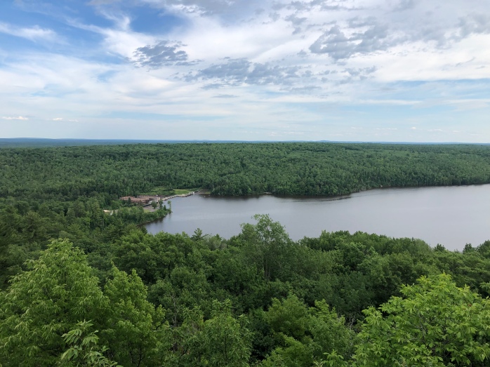
The Trap Hills amazed me immediately. The trail was arduous but so rewarding by granting some of the best views I’ve ever seen, not just on this trail. “This is AWESOME!” I thought. I was so excited to see what the next 30 miles brought.
Charmed by a perfect camping spot on top of one of the hills in a maple grove that had an amazing granite bald nearby with million dollar views, I set up camp early and ate my dinner grinning from ear to ear. I fell asleep to the sound of the wind in the maples, and heat lightning flashing outside.
At 3:45 a.m., a huge crack of lightning startled me awake. Thunderstorms raged until 7 a.m. I tried to fall back asleep all night, but couldn’t. I got hiking too late for how bad the heat has been, and felt terrible right away. The views were unbelievable, magical, but I was suffering, and finding it hard to really take in their grandeur.
At noon, I was forced to take a long break when I discovered I’d managed to over hydrate, which can be as dangerous as dehydration. Staying hydrated in this heat and humidity has been a challenge. Warning, this is a little gross. My trick to stay hydrated correctly is to monitor the color of my urine three times a day: morning, noon, and night. I urinate into a clear zip lock baggie, and check the color. My urine was clear, meaning I needed more salt. Most of us are familiar with dehydration, but an equally dangerous condition can develop if you drink too much water and get too few electrolytes and salt — hyponatremia.
I got hiking again after an hour, but I’d only made it about 4.5 miles. By the time I got to Whiskey Jack Creek, I could tell the heat was really getting to me. I started splashing water onto my head, face, neck and back, before finally taking my hat off and just dunking my whole head in the creek. I felt better. I was starting to worry about heat exhaustion. I’d been managing the heat so far by not overexerting myself, but that was impossible in the Trap Hills. It feels like there isn’t a level stretch of trail in the entire 30+ miles. Even on the hilltops, you’re climbing up and down constantly from one ridge to another. I started carrying a third liter of water not only for extra drinking water, but also to pour over my head if I started feeling too hot.
I finally hit a flat stretch toward the end of the day. I’d only hiked 8.5 miles in 7 1/2 hours of hiking. To have any chance of getting to town the next day, I needed to do at least another 6-7 miles that night.
The previous night’s four hours of rain had flooded the trail. As I tried to move quickly through mud patches, I was suddenly overcome by a powerful homesickness. I cried for a minute, but didn’t stop hiking, of course.
The sudden intensity of my homesickness is what finally got me to wonder if something might be wrong with me. Physically, I’d been struggling all day, but that struggle made sense. I was hiking the incredibly difficult Trap Hills in incredibly difficult conditions — wet, hot, and humid. To have my mental state change so suddenly was odd.
The temperature started to cool, and the forest was shady, so I picked up the pace, hoping to get back on top of a ridge to camp. Instead, the wind started gusting violently. The trees shook and swayed. I watched, my apprehension growing. Thunder growled a few miles away. I started hustling down the trail, looking for any place flat enough to pitch a tent, but I was in the middle of a marshy area.
The storm chased me down the trail. I finally saw a clear patch beneath some hemlock trees off in the woods and ran to set up my tent as the skies opened. Everything got wet. A line of thunderstorms, seven total, rolled over my head as night fell. I set my alarm for 5 a.m. with a plan to get as many of the remaining 16 trail miles done as I could before the heat. I had another 6-mile roadwalk to town from the trail, too.
The next morning, I woke up, struck camp fast, and got hiking by 7 a.m. I climbed up another Trap Hill, tried to appreciate an amazing view, followed the trail down off the bald, and fell again on a wet rock. I got luckier this time, no pointy rocks to jab me, but the fall forced me to admit that something was really wrong. I was too weak. I was dangerously weak. I had no idea what was wrong; there were too many possibilities. I just knew I didn’t feel safe anymore. At the first forest road I crossed, I sat down, and remembered Sara telling me as she and Guy headed back to their truck, “If you need any help, message me.” I hoped I wasn’t creating the memory. I pulled out my satellite communicator, and sent her a message asking if there was any way she could pick me up and bring me to town. I was still 19-miles away.
These satellite communicators can take a long time to transmit a message due to the fact the satellites are on a 20-minute orbit around earth. Sara could be busy at work and not reply. As the InReach gave it’s little chirp that the message had been sent, I sat there as the reality of my situation sunk in. I was physically unable to keep hiking. I had no way to get myself to town. I was running out of food and battery power. Worst come to worst, I could always pitch my tent, send my mom a message to let her know I was going to be late to town, and see if a day of rest would be enough to make me feel better enough to hike myself the 19 miles to town.
When I decided to undertake this trek, I knew I’d be taking risks, but I hoped none of my fears would be realized. Plan for the worst, hope for the best. As I waited for Sara’s reply, I felt my separation from my community, from the safety of town, keenly.
Thankfully, Sara’s reply came quickly. “I can come get you this afternoon,” she wrote. Relief and gratitude washed through me. I stared across the road at the trail heading west. I had no idea how I’d get back here. Would I have to skip miles? But I knew I’d made the right decision.
Sara arrived at 4 p.m. and drove me to the Konteka Black Bear Lodge in White Pine. I’ve met many trail angels on this trip. I’ve been overwhelmed many times by the lengths to which total strangers have gone to help me, but I am extra grateful to Sara for helping me off the trail. I don’t know what I would’ve done without her. The next day, it became clear why getting of the trail was the best decision, and that I wouldn’t have been able to get myself to town, even with a rest day.
At the lodge, I bought us dinner to say thank you, and then we parted ways. I lay down as soon as I got to my room and called my mom to tell her what had happened. I’d planned to go home for a visit once I finished hiking through Wisconsin, but I told her I was coming home as soon as I got to Ironwood a few days away. At this point, I still wasn’t sure what was going on, and thought a rest day might sort me out.
The next morning, I started to feel really sick. Body aches. Muscle cramps. Feverish. Chills. Then an intense stomach pain started, and diarrhea. After a few hours like this, I realized not only was I too sick to risk returning to the Trap Hills the next day, I was too sick to hike for a few days. I called and cancelled my reservations for Porcupine Wilderness State Park.
At the front desk, I asked if a staff member would be interested in making a few extra bucks to drive me to Ironwood, where I could catch a bus to Duluth, and then home. A wonderful woman named Cindy insisted on driving me for free.
I caught the bus home to St. Paul. I’ve officially been benched by my doctor until some lab tests come back. I still have no idea what made me sick. Hopefully, I’ll know more soon. I’m feeling better, and I’m hoping to be back on the trail in a couple days.
One of the major benefits of hiking the North Country Trail is that almost 900 miles of it runs through my home state, which means for the middle third of my hike, I am close to home. I knew that if I needed to get home quickly for any reason, I could. And I did. I’m very, very grateful to everyone who helped me to safety.
Section: Marquette to the Trap Hills
Miles: 180
Total miles: 820

Annie, Glad to hear that you made the wise choice to get off the trail for a few days. Can’t help but wonder if heat exhaustion is part of the cause (have had issues like that). Those are some rough miles as I personally know. Hope to hear soon that things are going better and that you can hike onward!
LikeLike
Thanks so much, Gail! I just looked up the symptoms for heat exhaustion and it sounds like it’s definitely possible. When I get back to the trail, I will definitely have to be more careful to actually get moving much earlier in the day so I can take a long break during the worst heat, I think. Especially while I’m still in this rugged terrain.
LikeLike
We’ve been thinking about you a lot, Annie, and very happy that you got home safely to recover. We would love to help in whatever way you need when you get to western MN (Maplewood State Park and beyond.)
LikeLike
Thank you so much, MO! Would you mind sending me an email through the Contact page of this website with your contact information? The further I progress, the more I appreciate offers of help, especially with how this last section went. Thank you!
LikeLike
Get yourself well. Hope it turns out to be nothing serious.
LikeLike
Thanks so much, Joan! I’m feeling pretty good now, so I’m hopeful I can get back out there soon.
LikeLike
Annie- we met you at the MQT potluck. Glad to hear that you were smart enough to know when you needed to seek some help. Hope it’s nothing serious and that you are enjoying some R&R time.
LikeLike
Thank you, Judi! I have a very good cuddle buddy right now 😁 🐶
LikeLike
THninking about you and hoping the rest helps. The heat has been oppressive. Take care! If we are any where near you in a couple of weeks I will leave a message here to see if we can help in anyway.
LikeLike
Thank you so much, Krista! Yes, I’m going to have to make some adjustments to better deal with it, I think. Trail naps lol?
LikeLike
Great blog Annie. You are a trooper!! Hope you are feeling better quickly and that your motivation increases proportionally to your increase in strength. Happy hiking girl!.👣🌲🍁
LikeLike
Thanks, Nancy! I’m feeling lots better now and hoping for the all clear soon. I was already missing the thrush song this morning.
LikeLike
Annie, you are amazing. What a wonderful way with words you have too. You were smart to take a break and I’m glad you’re feeling better. I hope all is well with your tests and that you are able to get back to the thrush songs soon! Thanks for the tips on the flagging in the McCormick; John and I plan to backpack that in August from Crag Lake SP. We are thinking of you and very glad you took time to rest and see your pup!
LikeLike
Thanks so much, Dove! I hope you have a great hike up there. The trail was pretty easy to follow otherwise, and the bugs really weren’t bad. Thinking of you guys too! I think about all the amazing people I’ve gotten to meet along the way a lot on the trail 😁
LikeLike
Here’s the blog of the woman walking the NCT.
Sent from my iPad
>
LikeLike
I can understand how one could feel ready for anything after hiking some of Minnesota’s constant ups and downs. Some of the SHT is No Joke!! Can’t imagine what the Trap Hills felt like! Hope you’re on the mend and will be returning to the trail soon!
LikeLike
Thanks, Carrie! I’m hoping that the Trap Hills won’t kick my butt quite as hard if I’m not getting sick, lol. We’ll see soon, hopefully!
LikeLike
Glad you are on the mend! Let me know if you need a shuttle back to the trail 🙂
LikeLike
Thank you so much! I definitely will. I so appreciate you.
LikeLike
Annie, be sure to let the three Wisconsin NCT chapter’s know when you get back on the trail, so we can expect you. HTG, CHE, BSC, @northcountrytrail.org.
LikeLike
I will for sure! I’m hoping some chapter members might want to join me for a day hike. Thank you, Peter!
LikeLike
I really enjoyed reading your story. I am a trail maintainer in Pennsylvania and saw the link to your blog from an email from National. I love hiking and have had many moments where I have looked around and thought “this is truly amazing and beautiful “
Good luck to you!
LikeLike
Thank you so much, winelegs! (There has got to be a great story with that trail name). I had so many moments like that this past week after returning to the trail. After such a rough stretch, I was really grateful to feel my soul singing out there again.
LikeLike
Annie, we ran across your post in the “trailbox” on the bridge just west of Canyon Falls a couple weeks after you had gone through. We were vacationing in the UP from Wisc. We had thought about hiking the Trapp hills section but were intimidated by our lack of knowledge of the trail along with the flys and mosquitoes! We hope to try in the fall.
Really enjoying following your adventure, you’re an inspiration to us… wishing you many more happy trails.
LikeLike
Thank you, Ann! Even in July, the flies and mosquitos were very thin in the hills, maybe because of their topography. I hope to go back and hike them in the fall someday. The views were incredible. With the leaves changing colors? I’m sure it’s phenomenal.
LikeLike
Thanks for sharing your story and I hope you recover soon!
LikeLike
Thanks, Missy! Feeling good and I’m back on the trail 😁
LikeLike
Still haven’t been too Top of the World but this seemed like one hell of a time.
LikeLike
It was! Highly recommend. Marquette seemed like a paradise city for anyone who enjoys outdoor activities like hiking, biking and skiing, but also had more public beaches than I’ve ever seen in a city on Lake Superior. And there were so many “Marquette” mountains that it felt like there’d be a place to watch the sunset for every city resident in peace and solitude. The local chapter even put reflective blazes on one of the spurs up to a favorite sunset spot to make climbing down in the dark easier to follow the trail. Cool, huh?
LikeLike